Western North Carolina 2024 flood (Asheville)
Turning to 2024 in Western NC and the remnants of Hurricane Helene, the area of the rain and floods is 1000s of square miles in several states. It is hilly and mountainous. All types of built environments are present. There is storm infrastructure, as well as many dams built for both hydropower and to manage extreme precipitation.
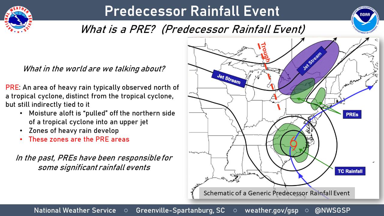
Just prior to Helene, there was a drenching rain than had filled reservoirs and caused some flooding. This fact had been mentioned in some forecasts, and basically stated that the ground was saturated and that the reservoirs were full. 1Note, this was true earlier in 2024 in Houston, Texas floods. The National Weather Service (NWS) Greenville-Spartanburg SC Weather Forecast Office, provided an excellent analysis of what it describes as Helene’s predecessor rainfall event.
So why did we see so much rain in the days leading up to Helene? We experienced what meteorologists commonly refer to as a Predecessor Rainfall Event – or PRE. A cold front stalled to the west of the mountains with multiple days of thunderstorms that produced heavy rainfall well in advance of Helene. By the time Helene arrived overnight Thursday and into Friday morning, rivers were already swollen and the ground saturated, as up to 10-15″ of rain had already fallen during the PRE. Additional heavy rain from Helene had nowhere to go and drained directly into the swollen creeks and rivers, the result of which was catastrophic and historic flooding across western North Carolina.

From looking at the surface, we see the ground as saturated and the reservoirs at capacity. It is a logical flaw to disconnect the precursor event from our warming climate. As with Hurricane Helene it was a weather event occurring in a warmer and warming climate, and hence, would be expected to have an increment of increased precipitation compared to a historical event. It contributes to the accumulation of water, as opposed to being, primarily, an intense and instantaneous event.
Here is the (excellent) forecast and warning from the NWS Greenville-Spartanburg SC Weather Forecast Office.
US National Weather Service Greenville-Spartanburg SC
*URGENT MESSAGE*
This will be one of the most significant weather events to happen in the western portions of the area in the modern era. Record flooding is forecasted and has been compared to the floods of 1916 in the Asheville area. The impacts from this event are expected to be greater than Tropical Storm Fred from August 2021, the mountains in 2004 from Frances and Ivan, and in Upstate South Carolina the Saluda River Basin flooding from 1949. We plead with everyone that you take every single weather warning very seriously through the entirety of this event as impacts will be life-threatening and make sure to have multiple ways to receive the alerts. The protection of life and property is the overall mission of the National Weather Service, and we pledge to stand by the folks of the western Carolinas and northeast Georgia. We cannot stress the significance of this event enough. Heed all evacuation orders from your local Emergency Managers and go to a storm shelter if you do not feel safe at your current location.
Hurricane Helene will make landfall later this evening near the Big Bend of Florida. Significant to catastrophic, life-threatening flooding will occur along and near the Blue Ridge Escarpment. Historic flooding will be possible in this area as an additional 9-14″ of rainfall will be in store. Many landslides will occur as a result, with a few large and severely damaging slope failures or debris flows are likely.
Possible hurricane-force gusts in the North Carolina mountains, northeast Georgia, and the western portion of Upstate South Carolina. 60-70 mph wind gusts possible elsewhere. The combination of strong winds and super saturated soils will lead to widespread trees down and numerous power outages.
In this message from the National Weather Service, historical reference is made to numerous inland hurricanes, especially in Asheville, NC, as well as the flood of 1916. In 1916, two hurricane remnants made it to Asheville in quick succession.
Record flooding was predicted by NWS.
I have established that flooding from the inland propagation is a recurring weather event in the eastern US, and, in fact, there are several local regions that have seen several floods over the past 100 years. It is, also, the case that in 2024 in Asheville, NC and surrounding counties, the ground was all ready saturated.
What, then, is the role of climate change?
Any attribute that is associated with a hurricane can be affected by global warming. There are two which have a more definitive signal than others. First, is the increased storm surge due to sea level rise, which is not relevant to this scenario. The second is more extreme and more precipitation due to higher temperatures, especially sea surface temperatures. More than any weather feature, hurricanes bring oceanic air to the interior of the continent. Therefore, extreme and record precipitation become a standard scenario.
What we are experiencing as extreme in the present time should be treated as representative of the coming years. Because of continued warming, we will be seeing even more extreme events in the coming decades.
There are many types of storms; hurricanes, severe thunderstorms, and tornadoes are common topics. We get wrapped in whether the particular types of storms are are changing – and how. This is problem of whether the signal has yet emerged from a noisy background – it will. All rain producing storms are, now, in a warming world and are likely to cause extreme precipitation.
The average recurrence interval (ARI) is how often does a rain event of a given magnitude return. It does not matter what type of storm. A 1-in-100 year storm is expected once ever 100 years. This is often interpreted as a 1% chance in any individual year.
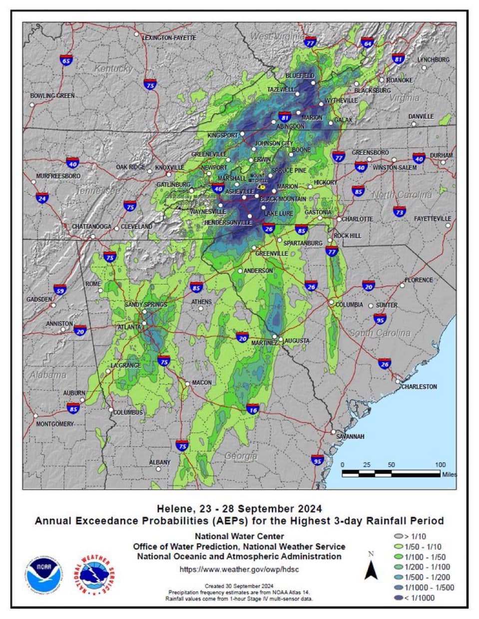
We know that there is an ARI trend in the eastern U.S.. with storms that used to be rare occurring more often. In the figure, below, the annual recurrence interval is shown for Hurricane Helene. The dark blue is a recurrence interval of more than 1000 years, which means it is both rare and, practically, unprecedented.

Given the established trends in ARI, it is difficult to argue that there is not a substantial boost to the precipitation that is due to the accumulation of heat and the high seas surface temperature the fuel the storm and set the background moisture environment. A provisional study out of Lawrence Berkeley National Laboratory suggests that the boost from warming for Helele is as much as 50%.
Hurricane Helene in the mountains of North Carolina, South Carolina, and Virginia is a recurring type of weather event, influenced by the accumulation of heat due to greenhouse gas increases. We have made the storm more dangerous with the extra heat and moisture it contains due to global warming.
Neither the built environment nor the natural areas of the southern Appalachians can receive that much water without alteration. The flood has changed the landscape, and challenges our intuition about what, how, and where we build. As we build back, it must be assumed that floods of equal or greater magnitude are likely to occur. There is no solace to be taken in the event being more rare than a 1-in-a-1000 year event. That rarity is based on our historical climate, which is no longer our climate. Though such an event is still expected to be relatively rare, we do not the average recurrence time. We need to expect such events to be more common. They require us rethink our relation with weather and climate.